
INDOOR
OUTDOOR
Connected Worker · Indoor and Outdoor

Connected Worker RTLS That Does Not Stop at the Door

Most sites run one system inside the building and another one across the yard, and no report that crosses between them. SmartX HUB connected worker RTLS treats both as one world: indoor position and outdoor position write into the same underlying record, so lone worker, dwell, restricted areas and man-down are evaluated by one policy wherever the person happens to be standing.

One safety policy, indoor and outdoor Lone worker and man-down Auditable near-miss history Evacuation accountability
Executive Dashboard

The Whole Site on One Screen

Assets and people, live positions and zone density, safety exposure and the week's trend — in one view instead of four systems. Every figure carries its direction of travel, so leadership reads context rather than a snapshot. And the strip along the bottom reports anchors, gateways and coverage, which means the dashboard also tells you whether the numbers above it are still being fed.
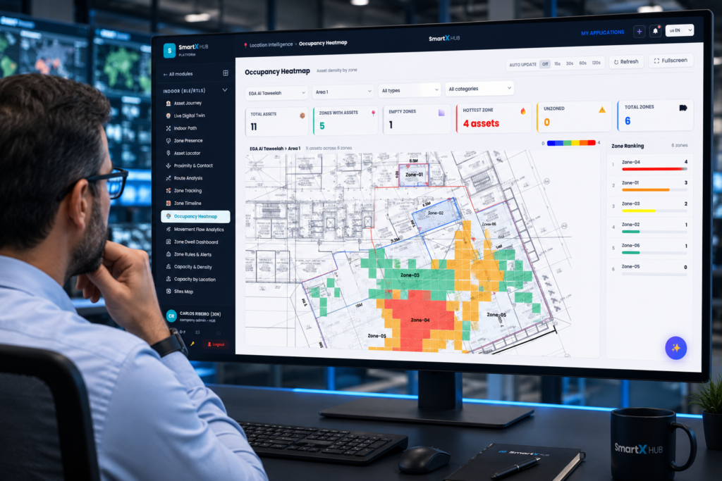
occupancy heatmap showing worker density by zone on a facility floor plan.
One World, Two Position Sources

How Connected Worker RTLS Works Indoors and Outdoors

Indoors, position comes from anchors and the containment unit is a zone. Outdoors, position comes from satellite and the containment unit is a geofence. Almost every platform treats those as two products, which is why a supervisor ends up with one screen for the plant, another for the yard, and a spreadsheet to answer any question that spans both.

SmartX HUB resolves them into one. Motion derived from position — speed, moving or stationary, and man-down — is written into the same time-series tables that physical IoT badges feed. Because the data lands in the same place, the same rules, the same dashboards and the same alerts apply on both sides. Nothing needs translating at the door.

Concept Indoor Outdoor
Containment unit Zone, resolved against the true polygon rather than a bounding box Geofence drawn on the map
Position source UWB, Bluetooth AoA and BLE anchors GPS and LoRaWAN uplinks
Motion and speed Derived from position history, with hysteresis so a badge on a boundary does not flap between zones Derived the same way, with a jitter gate so ordinary satellite noise never reads as movement
Rules Zone rules with dwell limits, restricted flags and lone-worker risk Must-stay, must-not-enter, curfew and maximum dwell
History Zone timeline, dwell analytics and workforce replay Geofence timeline, dwell and animated route replay
Safety reports Unified. Lone worker, dwell exceeded and restricted-entry audits merge indoor zones and outdoor geofences into single reports, and each zone or geofence carries its own safety configuration edited in the same screen.

The walk from plant to yard

A technician leaves a restricted room, crosses the loading bay and drives to a remote substation. Indoors the badge is positioned by anchors; outdoors the tracker reports by satellite. There is no handover to configure and no second identity to reconcile, because both write to the same person record. If they stop moving for longer than the configured window, the man-down signal is the same signal either side of the door.

Coverage you can prove

Safety systems fail quietly when coverage degrades. A coverage map shows where positioning is solid and where it is ambiguous, infrastructure health separates an anchor that is offline from one that is simply out of range, and a silent-device filter flags trackers that have stopped reporting — the difference between a vehicle parked and a battery dead. Read more on choosing a technology.

Safety Outcomes

Six Things That Stop Being Guesswork

Safety leaders rarely need more data. They need the specific answer, at the moment it matters, with a record afterwards that stands up to an auditor. Each of these is a report the platform derives from position it is already collecting, aligned with the management-system thinking behind ISO 45001.

Who is working alone

A live list of anyone alone in a risk-flagged zone or geofence beyond a set number of minutes, so supervision is directed rather than assumed.

Someone who stopped moving

Man-down is raised when a person shows no motion beyond a configurable window. It applies to people only by design, so a parked vehicle or an idle machine never triggers it.

People and vehicles too close

Proximity events are typed, graded by severity and stored with a debounce, giving a defensible near-miss frequency rate with daily figures and export instead of anecdotes.

Entry into restricted areas

An audit of every entry into an area marked restricted, merged across zones and geofences, ready for the inspection rather than assembled after it.

Time spent where it is not safe

Dwell limits per zone or geofence flag anyone over the exposure window for that area, which matters wherever heat, noise, cold or chemical exposure is time-bound.

Who has not reached the muster point

An evacuation view ranks time to muster per person and names anyone who never arrived, so the search is directed at four people instead of the whole site. Works for drills as well as the real thing.

And the Operational Payoff

The Same Data Answers the Productivity Questions

Safety justifies the deployment; operations is what makes people log in every day. Once connected worker RTLS is running, the position history already collected answers a second set of questions at no extra infrastructure cost.

Where the work piles up. Occupancy by zone against capacity shows crowding and dead space, which is the basis for rebalancing a shift. See staff workflow.
Whether the round was walked. Verified presence at each checkpoint turns a signature into evidence. See operator rounds.
What actually happened. Replay a person or a route over a chosen window instead of reconstructing an incident from three conflicting accounts.
Who was near whom. Zone-level contact history for the rare occasion it is needed, without a separate system to maintain for it.
Tracking people is a governance decision before it is a technical one

Locating workers touches consent, works councils and data protection law, and a deployment that skips that conversation tends to fail on adoption rather than on technology. Two design choices make the discussion easier. First, the analytical views derive from data the platform already writes rather than logging anything extra — configuring what a supervisor can see does not change what is stored. Second, visibility is bounded by the same role profiles, group filters and field-level permissions used everywhere else, so a shift lead sees their own area rather than the whole workforce.

Purpose limitation, retention periods and who may open a replay remain your organisation's decisions. We recommend writing them down before enrolment starts, and involving worker representatives early rather than presenting a finished system. Where data cannot leave the site at all, the platform can be deployed on premise.

Technologies behind it

Bring One Area, Indoors and Out

Pick a building and the yard beside it, tell us the safety questions you cannot answer today, and we will show what the reports look like when both sides share one policy.

FAQ

Connected Worker RTLS — Common Questions

Answers to what safety, operations, IT and worker representatives ask most when evaluating people-location technology across indoor and outdoor areas of the same site.

What is connected worker RTLS?
A real-time location system applied to people rather than only to equipment, used to answer safety and operational questions as they happen. Connected worker RTLS covers where someone is now, which area they are authorised for, how long they have been exposed to a condition, whether they are moving, and whether they reached the assembly point during an evacuation. The distinguishing feature here is that it works the same way indoors and outdoors instead of being two separate deployments.
Do we need two systems for indoor and outdoor areas?
No, and that is the main reason this page exists. The position source differs — anchors indoors, satellite outdoors — but the motion and presence they produce are written into the same underlying tables that hardware badges feed. Lone worker, dwell exceeded and restricted-entry reports therefore merge both worlds into single outputs, and each zone or geofence carries its own safety configuration edited in the same screen. One policy, two position technologies.
Which technologies are used, and how do we choose?
Indoors the choice is driven by how precise the answer has to be. Zone-level presence from gateways and beacons is enough for mustering and area authorisation, while UWB and Bluetooth AoA are used where sub-metre separation between a person and a moving vehicle actually matters. Outdoors it is GPS, with LoRaWAN for long-range low-power reporting. Mixing several on one site is normal; compare technologies sets them side by side.
How does man-down detection avoid constant false alarms?
Three things keep it usable. The no-motion window before a signal is raised is configurable per organisation, so a role that legitimately stands still for long periods is not treated like a role that never does. Position noise is filtered before it counts as movement, through a minimum-distance gate outdoors and agreement between consecutive fixes indoors, which stops a stationary badge from appearing to drift. And man-down applies to people only by design — a parked vehicle or an idle machine on a tracker never produces one, no matter how long it sits.
Is this employee surveillance? How do we handle privacy?
It is a fair question and it deserves a straight answer rather than reassurance. Locating workers is regulated in most jurisdictions and subject to consultation in many, so treat it as a governance project with a technical component. Two things help. The analytical views derive from position the platform already records, so changing what a supervisor can see does not change what is stored. And visibility is bounded by the same role profiles, group filters and field-level permissions used elsewhere, so access is scoped to an area rather than to everyone. Purpose limitation, retention and who may open a movement replay stay your decisions — define them before enrolment, involve worker representatives early, and deploy on premise if data cannot leave the site.
What happens during an evacuation?
The roll call starts from a live on-site count rather than a printed list. As people arrive at the assembly point the view ranks time to muster per person and, more importantly, names anyone who has not arrived — which is the number the incident commander actually needs. Because entry and exit events are already flowing from access control, contractors and visitors are counted too. The same view runs for drills, so you can measure whether practice is improving. See emergency roll call and emergency preparedness.
How are near misses between people and vehicles handled?
Proximity between tracked objects is evaluated continuously against a distance threshold you set. Pairs are typed, so person-and-vehicle can be treated more seriously than person-and-person, and each detection is graded by severity and stored with a debounce so one prolonged encounter does not become fifty records. The result is a near-miss frequency rate with daily figures and export — a leading indicator you can trend, rather than a count of the incidents people happened to report. Confirmed events can open a full incident record.
What do workers actually carry?
Usually the badge they already carry, extended with the right radio for the site, or a tracker attached to a helmet, vest or belt where a badge is impractical. Outdoor roles typically carry a GPS-capable device. The practical constraint is rarely the technology and usually the wearing habit: anything that has to be remembered, charged daily or removed for a task will be, so the enrolment conversation should cover charging routine and spare stock as seriously as it covers accuracy. Reusable equipment can be issued and returned through PPE tracking.
Can we start with one area and expand?
Yes, and starting narrow is what we recommend. Most deployments begin with the single area that carries the clearest risk — a confined space, a high-traffic vehicle route, a remote yard — and one question the team currently cannot answer. Coverage is validated before anyone depends on it, using a map that shows where positioning is solid and where it is ambiguous. Expansion afterwards is configuration rather than a new project, because zones, geofences, rules and roles all sit on the shared record described on the enterprise platform page.
How does this differ from your other people-related solutions?
This page is the location layer that the others sit on. Access control governs the boundary and who may cross it. Staff duress is the worker-initiated alarm and the response that follows. Emergency roll call is the evacuation case in depth. Staff workflow turns the same movement into productivity insight. They are complementary, all running on one record. For background reading, connected worker safety covers the wider category, and to see it applied to your site, book a demo.
error: Content is protected !!